Killer Arctic freeze to last for up to a WEEK: UK braces for snow
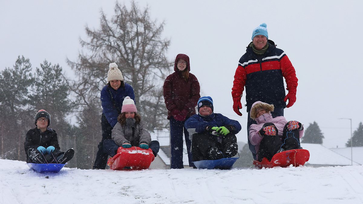
A brutal Arctic freeze is set to grip the UK for up to a week, with the Met Office warning that daytime temperatures will barely rise above 0C.Snowfall is forecast across England, Wales, Scotland and Northern Ireland on Friday and Saturday amid a bitterly cold start to 2026. It comes as temperatures plummeted to almost –10C in Aberdeenshire overnight as people brought in the New Year - and freezing winds from the extreme north moved in. This morning, the Met Office issued additional weather alerts for snow and ice for more parts of the country which will see the mercury dip into the negative early on Friday and Saturday.Chief forecaster, Neil Armstrong, said: 'With Arctic air now covering most of the UK, very cold weather will continue through the weekend, with minus double figures overnight in places and daytime temperatures struggling to rise above 0°C for some.'It looks like this cold spell could last well into next week and wintry hazards will continue with more weather warnings likely. It is therefore important people keep up to date with the latest forecast and warnings and plan ahead.'Warnings have been issued by health chiefs and forecasters over severe wintry conditions that might even feel colder than the icy waters of a New Year's Day dip. But swimmers have also been warned to take care if taking to the waters on Britain's east coast due to a risk of large waves and higher than normal tides whipped up by strong winds today - following last week's Christmas tragedy in Devon. Alongside existing warnings for swathes of England, Scotland and Northern Ireland, the forecaster issued a yellow warning for snow and ice on Saturday covering the East Midlands, Yorkshire and the Humber and the North East. A car drives through snow at Moy near Inverness on New Years Day (1st Jan 2026) as parts of the North of Scotland woke up to a dusting of snow with more forecast The Met Office has issued yellow and amber warnings for snow and ice covering large parts of the country for FridayAn amber warning for heavy snow showers - meaning disruption is more likely and widespread - has been issued this morning for the Highlands north of Inverness, Moray and the entirety of Aberdeenshire, from 12pm tomorrow until 12pm Saturday. Vehicles could become stranded with snow of up to 10-20cm at low levels and 40cm on high ground; drivers have been warned to prepare a winter kit with clothing, food, water, a blanket and a car charger should they be driving in affected areas. It's the first amber alert since November, when one such warning was issued for the North East of England - and only the third in the last year. Meanwhile, the UK Health Security Agency (UKHSA) has upgraded cold weather health alerts across England to 'amber' – amid concerns that the elderly and vulnerable are more at risk of succumbing to the brutal conditions. Where are the weather warnings? Snow and ice for northern Scotland, 6am today to 11.59pm FridaySnow and ice for Northern Ireland, 12am Friday to 10am Friday Snow and ice for south and west England (including London) and Wales, 12am Friday to 12pm Friday Snow and ice for the North East and East of England, 12am to 11.59pm Saturday Previous 'yellow' alerts across the Midlands and South have been upgraded to amber – amid expectations that the biting chill is expected to have a substantial impact on health services for some time – alongside alerts in the North.The agency says it expects a rise in deaths among those aged 65 or over and those with long term health conditions.Health chiefs also predict a 'likely' increase in demand for health services and that people will struggle to heat their homes to an ideal 18 degrees Celsius.Hospitals may also struggle to keep temperatures at recommended levels – and could suffer staffing challenges due to disruption to transport. Dr Agostinho Sousa, head of extreme events and health protection at the agency, said: 'As the colder weather sets in it is vital to check in on friends, family and neighbours that are most vulnerable.'The forecast temperatures can have a serious impact on the health of some people, leading to increased risk of heart attacks, strokes and chest infections, particularly for individuals over the age of 65 and those with pre-existing health conditions.'The amber alerts will be in place until 10am on January 6. Elsewhere, the Met Office has issued yellow weather alerts for ice and snow covering most of Wales, the West Midlands, the Cotswolds, London and Kent, swathes of the Scottish Highlands and islands and the entirety of Northern Ireland tomorrow.Forecasters have warned of potential disruption on the roads and rails in the south, while rural communities face being cut off by snow or even suffering power cuts.People are also being warned to take care on icy surfaces due to the risks of slips and falls as sleet and snow clears. Join the debateAre the government and health services doing enough to protect vulnerable Brits during this Arctic freeze? The UK Health Security Agency has issued amber alerts covering all of England – warning that elderly and vulnerable people are at risk of dying in the cold conditions Temperatures today will remain in single digits - with colder to come in the days ahead A Canada goose goes for a skate on some ice at a Somerset nature reserve on New Year's Eve. Similarly slippy conditions are expected across the UK in the coming days A woman walks her dog in Touchen End, Berkshire. Temperatures will drop further as 2026 begins, with snow and gale force winds set to batter the north of the country Families have fun in the snow in Carrbridge in the Scottish Highlands A frosty New Year's Day walk in Dunsden, Oxfordshire. Chilly conditions are expected to continue throughout this weekThe alerts are in place until 10am in Northern Ireland and 12pm in England and Wales, but will last until the end of Sunday in Scotland. A spokesperson said: 'This warning highlights the risk of disruptive snow showers and icy surfaces, particularly in northern and eastern areas, with impacts on travel and potential hazards for the public.'We expect this cold spell to persist into the weekend and on into next week, with further warnings possible as temperatures remain well below average and snow showers continue in places.'As Britain brought in the New Year last night, conditions fell to –9.6C in Braemar, Aberdeenshire, –6.9C in Yorkshire, –8.1C in Cumbria, –6.4C in Wales and –5.8C in Benson, Oxfordshire.Today, chilly conditions are expected nationwide, with highs of 5C expected in Belfast, 7C in London, 6C in Manchester, 3C in Edinburgh and 8C in Cardiff. In a post on X on Wednesday, the Met Office said a 'dip in the sea' on January 1 could even feel 'relatively mild compared to the wind chill that can be expected on land'. Snow up to 5cm deep could blanket some areas especially on higher ground in parts of North Wales and north–west England, according to forecasters. Heavy snow is also expected tomorrow in Aberdeenshire and the Highlands, with sleet in some parts of Wales, the West Midlands and London in the early hours of the morning.


Comments (0)