Met Eireann warns of changing conditions as temperatures drop
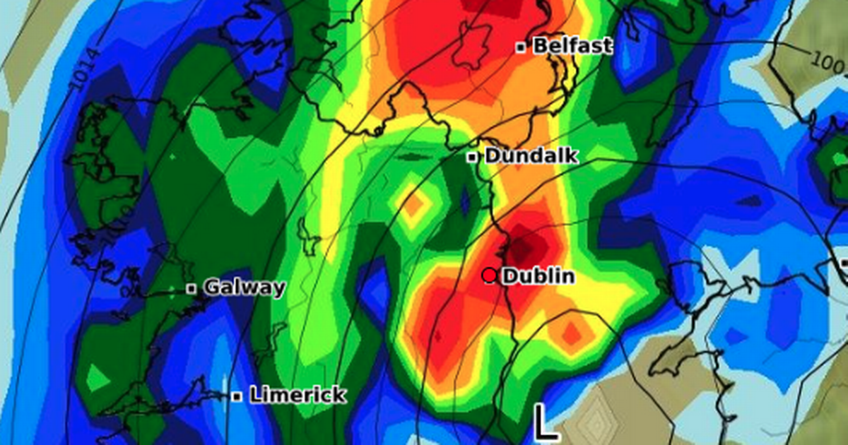
The weather is cooling and there's a warning over drops in temperature over the coming days. While we can expect plenty of rain and drizzle today, we're looking at a pretty mild day with temperatures hitting around 20C. We can expect some fog and mist too. As for overnight, it will be very similar with fog, drizzle and rain set for Dublin. Temperatures will drop to about 14C so a comfortable night overall. Met Eireann said: "It'll be mostly cloudy today, with outbreaks of rain and drizzle, along with mist and some hill and coastal fog. There'll be some drier and limited brighter intervals too. Feeling mild, with highest temperatures of 17 to 20 degrees, in light southerly or variable winds becoming fresher south to southwest through the morning and afternoon. "Cloudy tonight, with rain and drizzle moving up from the south, along with some mist and hill fog. Lowest temperatures of 14 to 16 degrees in moderate to fresh southwest winds, generally decreasing light to moderate." Friday will continue similar to Thursday, but there will be a change coming overnight. That's when temperatures are expected to drop too. There's a particular warning for Leinster and Munster with heavy rain on the horizon. Temperatures will drop overnight to around 9C. Met Eireann continued: "Rain, drizzle, mist and fog will clear eastwards on Friday morning, to leave a mainly dry, albeit fairly cloudy day overall. Some limited bright spells may develop for a time. Highest temperatures of 17 to 19 degrees in mostly light southwest to west winds. "An area of low pressure to the south of Ireland is likely to send up some rain from the south on Friday night. There's still uncertainty though as to how widespread the rain will become. At the moment though, it looks like Munster and Leinster are most likely to see some rain, especially southern and eastern parts, some of it heavy. Lowest temperatures of 9 to 14 degrees in light to moderate breezes, becoming mostly northerly and freshening in southern areas." As for the weekend and into next week, the weather will continue to run wet but there will be a big change in temperatures particularly overnight. By Saturday night they'll be as low as 6C. By Monday the high pressure will begin to make a return with sunshine on the way. It's expected to continue into the middle of the week, but uncertainty remains. Upcoming forecast: Saturday The area of low pressure to our south will continue to dominate our weather on Saturday. There'll be some heavy spells of rain, particularly in the south and east. While it may hold mainly dry elsewhere, there is the possibility of more widespread heavy, possibly thundery, rain. There's also the potential for it to become breezy or rather windy with freshening northerly winds, possibly stronger in parts. Highest temperatures of 12 to 17 degrees.The uncertainty continues into Saturday night, but there'll be further wet and breezy or rather windy conditions, especially in the east, but again with the potential to be more widespread. Lowest temperatures of 6 to 10 degrees. Sunday On Sunday morning, it's likely to be still be wet and blustery in the east at first, though the rain should clear eastwards through the morning. Otherwise it's going to be a cool, breezy day, with sunshine and a scattering of showers. Highest temperatures of 11 to 14 degrees and feeling cooler than that with the added wind chill effect from a fresh and gusty northerly wind, which will be stronger in some coastal parts. Monday By Monday, the winds will have moderated and while there'll still be a few scattered showers around, mainly in the north, it'll be mostly dry with some spells of sunshine, as high pressure becomes the dominant influence on our weather. Continuing cool with highest temperatures of 11 to 14 degrees with moderate northerly winds easing mostly light. Tuesday High pressure will continue to bring dry weather on Tuesday with a mix of cloud and sunshine. Highest temperatures of 11 to 14 degrees in light northerly or variable breezes. Wednesday By Wednesday, uncertainty comes back into the forecast. It's likely that high pressure may hold on to give continued settled conditions, but with a chance that a weather front will move in from the west, bringing a return to more unsettled conditions. Join our Dublin Live breaking news service on WhatsApp. Click this link to receive your daily dose of Dublin Live content. We also treat our community members to special offers, promotions, and adverts from us and our partners. If you don’t like our community, you can check out any time you like. If you’re curious, you can read our Privacy Notice. For all the latest news from Dublin and surrounding areas visit our homepage.


Comments (0)