
Remember me


The images and stories of flash flooding coming out of Victoria's Great Ocean Road overnight have been described as 'terrifying'. It's easy to see why.
Holidaymakers at Victoria's Wye River watched as cars were swept out to sea and a caravan park was rapidly inundated. Some had to get new clothes at an op-shop.
One resident at nearby Separation Creek told the ABC: 'We missed being killed probably by about ten seconds. We just ran for our lives.'
I've been studying floods and flood risks for decades. On the one hand, this was a shocking event, due partly to the bad luck of such a heavy downpour occurring in an area with many geographic risk factors for flash flooding.
On the other hand, it was not surprising. These one-in-hundred chance floods will occur somewhere every year, and with climate change these kinds of events will become more intense and more frequent.
In fact, due to global warming over the last 30 years, there is clear evidence the intensity of such thunderstorm events have increased by 15 to 20 per cent.
The challenge with these kinds of floods is that they are caused by thunderstorms; it's notoriously difficult to predict exactly where they will occur.
You might see a thunderstorm on the radar and know it's heading in a certain direction, but it's very hard to know exactly where it will actually impact.

Cars were swept out to sea and a caravan park was rapidly inundated

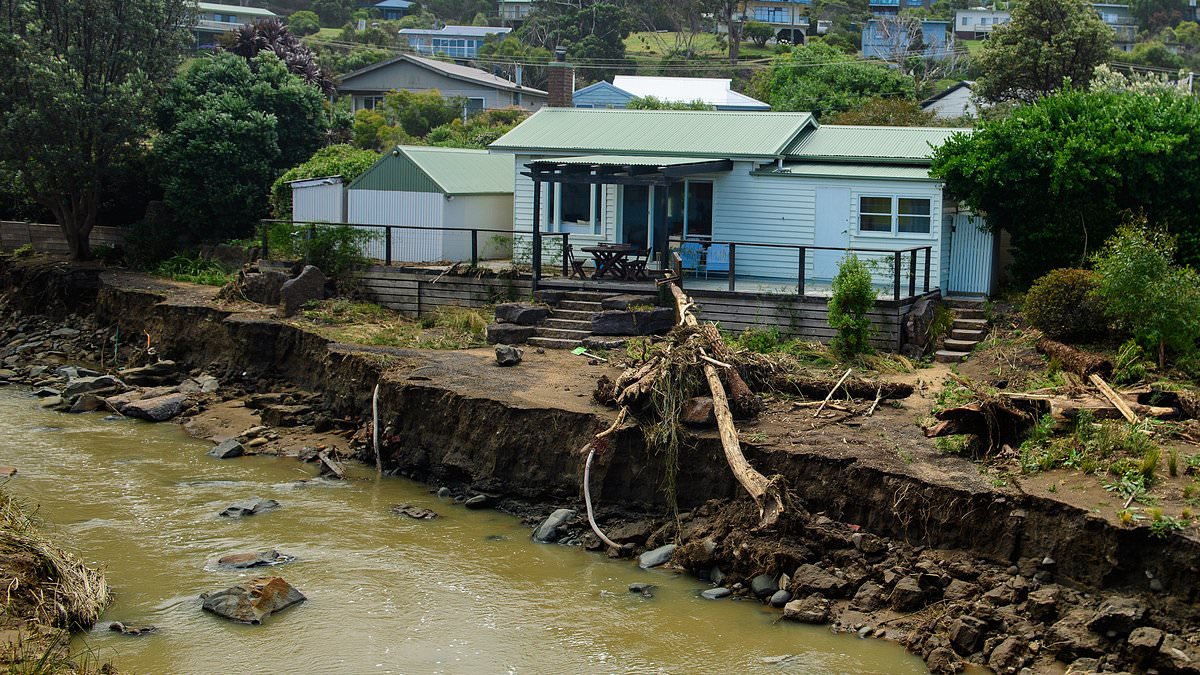
A house sits very close to a gouged out Separation Creek, after flash flooding near the Wye River in Victoria

With the flooding receded the wrecks of dozens of cars were littered across the landscape
In this case, it just happened to hit the Wye River catchment, which is particularly bad luck for the locals who live near the coast and the visiting holidaymakers.
This area features very small and steep catchments draining the southern slopes of the Otways (a forested mountain region in Victoria).
These catchments respond very quickly to thunderstorms; it doesn't take long for rainfall to produce runoff from all parts of the catchment.
This is a real problem for catchments along the surf coast areas of Victoria as there is little or no opportunity to provide effective flood warning.
At Wye River, the most intense part of the thunderstorm was only a tiny percentage of the whole area of forecast rainfall. That makes things really difficult to predict.
In a catchment like that, flash flooding can happen unbelievably quickly – things can go within minutes from okay to really dangerous.
All that was needed was maybe a few hours of intense rainfall. Most of the rain appeared to fall on the upper reaches of the catchment, so it wouldn't necessarily have been evident to campers and holidaymakers.
But once it's in the waterways, the floodwaters can rapidly shoot down the river system. The first anyone might know there is a problem is when the flood suddenly arrives.

One upturned car was swept out to sea then washed onto rocks after the Cumberland River flooded

The clean up is expected to last weeks

The flooding tore through the area before the owners could get to their vehicles

A supplied image obtained on Sunday, January 18, 2026, of flooding in Sydney's northern beaches
The best thing we can do to reduce risk is educate communities about what warnings mean and how to respond when authorities say there's a storm on the way.
If you're in a high risk area, you shouldn't just be saying, 'Oh it's just a bit of rain, we'll wait it out'.
Look at the effort governments have put into raising awareness about bushfire risk and response. They have worked hard on grading messages so people leave high risk areas when the risks are catastrophic, often before there are any fires in their actual area. We have learned to take such warnings seriously.
I don't think the community is there yet with floods – but we do need to get better at this.
The campgrounds in such areas are typically on nice flat grassy areas next to the river bank, so you can see why people camp and holiday there. But when floods arrive, that's the worst place to be.
So, what would I have done, as someone who knows floods?
If I was in a floodplain or on a flat area next to a river, and had a warning severe thunderstorms are predicted to occur in this region, I would probably – at the very least – get the kids up and drive to higher ground. At least, I hope I would.
Even though I am attuned to flood risks in my professional life, I can imagine being caught out in holiday mode and being slow to respond. I can well imagine staying put and hoping for the best.

Experts called for better warnings systems following the flash floods (pictured, large swells on the coast in north Sydney)

People in high risk flood areas were warned to not shrug off warnings and have plans in place
It can be difficult to think about risk when you're on holidays; it's easy to switch off and just think you'll wait the rain out.
Nature can be capricious, floods especially so, and with climate change we must be more aware of risks.
I spend a lot of time researching the impact of climate change on these events.
In Victoria, we can expect small floods will get smaller (due to drying soils), and large floods will get bigger (due to more intense rainfalls).
The risk of flooding will double by the end of this century. The impacts of floods caused by thunderstorms will tend to be larger.
As University of New South Wales professor Jason Evans explained to the ABC, a warmer atmosphere results in more water vapour.
More water vapour means more moisture in the rain, which can kick off massive downpours given the right conditions.
'The rain will fall over a similar period of time, but there was more water there, so it falls out more intensely,' Professor Evans said.

Stronger storms are possible if the climate becomes warmer (pictured, Sydney's north on Sunday)
A similar pattern is being seen in Queensland and NSW.
Authorities on Sunday downgraded a flood alert for a Sydney suburb after residents were evacuated due to rising waters sparked by torrential rains.
Flooding was 'receding and no further significant rise in flood levels is expected,' State Emergency Services said on Sunday afternoon, referring to the suburb of Narrabeen, a beachside area with a population of around 8,000.
Residents and holidaymakers in the low-lying area of New South Wales capital Sydney had been told late on Saturday to evacuate to higher ground due to dangerous flash flooding, according to state authorities.
Emergency crews responded to more than 1,700 incidents in New South Wales since the heavy rain hit on Saturday, the state authorities said.
A woman died on Saturday amid the wild weather after being hit by a falling tree branch near Wollongong, about 66 km (41 miles) south of Sydney.
Meanwhile, several flood warnings remain active across Central Queensland.
Ex-Tropical Cyclone Koji has continued to drive floodwater through several major catchments and killed more than 68,700 livestock.
Queensland Premier David Crisafulli warned the final toll would likely surpass 100,000.
River systems across the state are still rising as floods sweep through.
Those in affected areas have been asked to keep up to date with warnings and avoid floodwaters.
Comments (0)